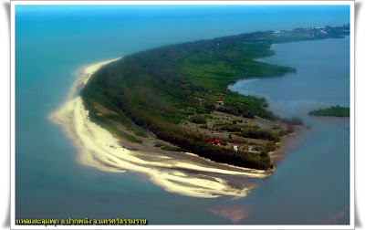
Pak Pha nang Coast and
Talumphuk Cape (ชายทะเลปากพนังและแหลมตะลุมพุก) The
sites of a severe storm in Nakhon Si Thammarat in 1962. The coast of Pak
Phanang is a long beach with the Talumphuk cape to the north jutting out into
the Gulf of Thailand like a crescent moon. The part where it is connected to
Nakhon Si Thammarat bay has some villagers, while the coast on the gulf has a
beautiful, pine-lined beach. To get to both places, take Highway No. 4013
(Nakhon Si Thammarat-Pak Phanang) and then 16 kilometres on a road to Pak
Phanang. Both sides of the road are shrimp farms and mangrove forests.
Pak Phanang is the
name of district means Sheltered Mouth, referring to the mouth of
the Pak Phanang river protected from the open sea by a long peninsula.
During the thesaphiban
administrative reforms the district was created in 1895 in the name Bia Sad (เบิ้ยซัด). And then was renamed to Pak Phanang; a name
first recorded for the area.
On October 25, 1962
Tropical Storm Harriet hit the district. The low Talumphuk peninsula to the
north of the district was completely devastated, and even in the town Pak
Phanang itself the storm surge made the water rise to 4 meter depth. The
flooding caused more than 1000 fatalities, and many more homeless.
Due to its geography Neighboring districts are (from the south clockwise) Hua Sai, Chian Yai, Chaloem Phra Kiat and Mueang Nakhon Si Thammarat. To the east is the Gulf of Thailand. The most striking geographical feature is the long elongated peninsula Talumphuk, which is formed of sand deposited by the predominantly northward current interacting with the outflow of the Pak Phanang River. The shallow bay formed by the peninsula is about 3 km wide at the mouth of the river and 10 km at the top of the peninsula. Originally the coastliine of the bay consisted of tidal flats and mangrove forest, however a lot of the western coast had been converted into shrimp farms.
 |
| Photo courtesy of Greenpeace: "Fisherman" |
A fisherman lays his catches
fish to dry under the sun. The fish come from the river basin which is the main
source for thousand of people as living along river. Now the river is
threatened by Electricity Generating Authority of Thailand's (EGAT) plan to
build a coal-fired power plant in Nakhon Si Thammarat province. Near shore
fishery, shrimp farming, Bird nest collecting, and rice farming are the main
source of livelihood of thousands of people in the province. Greenpeace stands
in solidarity with the people's movement, calling on the Thai government to
have political will and action and lead the country towards an energy
revolution by investing in renewable energy and putting in place more
aggressive energy efficiency.

No comments:
Post a Comment